|
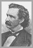
Bragg's
Situation on November 24, 1863
 n
the morning of November 24, Bragg’s nearly starved and
demoralized Army of about 32,000 faced a now well-fed Union force of
three Armies of about 70,000 men. On the morning of the 24th, Bragg
controlled Lookout Mountain and Missionary Ridge, by the evening of
the 25th, he had lost both. n
the morning of November 24, Bragg’s nearly starved and
demoralized Army of about 32,000 faced a now well-fed Union force of
three Armies of about 70,000 men. On the morning of the 24th, Bragg
controlled Lookout Mountain and Missionary Ridge, by the evening of
the 25th, he had lost both.
|
Reacting
to the assault on Orchard Knob, Bragg
ordered
a third of his troops on Lookout Mountain to Missionary Ridge. This
left only 4,000 thinly spread Confederates to defend Lookout Mountain. |
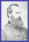
Grant's Plan To Secure Chattanooga
Generals Grant, Thomas,
and Hooker believed the top of Lookout Mountain was impregnable.
Surrounding the top of the mountain is the Palisades, a sheer rock
face 50 to 75 feet high. It runs from Point Lookout 20 miles south on
both the eastern and western sides of the mountain.
On the morning of
November 24, Grant's plan to secure Chattanooga and capture Bragg's
Army did not include using Hooker and his Army of the Potomac. Grant
planned to use Sherman and his Army of the Tennessee to attack the
north end of Missionary Ridge and drive the Confederates off. Grant,
however, decided to let Hooker make a "demonstration"
against Lookout Mountain. Grant
|
Grant
was using Hooker as a diversion. Sherman was scheduled to cross the
Tennessee River the morning of the 24th and attack that afternoon.
Grant thought Hooker's attack that morning would confuse the
Confederates and take some of the pressure off Sherman. |
Hooker's Strategy
Hooker knew the
Confederates had prepared defensive breastworks expecting an attack
up the mountain toward Point Lookout. Such an attack would be costly,
so Hooker devised another plan. Rather than going straight up toward
Point Lookout, he would attack the Confederate positions from the
south along the side of the mountain.
Up the Mountain
 About
7:30 am on the 24th, Hooker’s men under Geary crossed Lookout
Creek at Light’s Mill (just a few hundred yards east of
Wauhatchie). Here they surprised and captured 42 Confederate pickets
without firing a shot. The Union force of about 3,800 made their way
straight up the mountain's 1500 foot western slope. They formed a
line that stretched from the Palisades (just below Sunset Rock) to
Lookout Creek. About 9:00 am the line started toward the north end of
the mountain. In the assault, the men had to climb huge boulders,
cross deep ravines, and go through dense thickets of brush and timber. About
7:30 am on the 24th, Hooker’s men under Geary crossed Lookout
Creek at Light’s Mill (just a few hundred yards east of
Wauhatchie). Here they surprised and captured 42 Confederate pickets
without firing a shot. The Union force of about 3,800 made their way
straight up the mountain's 1500 foot western slope. They formed a
line that stretched from the Palisades (just below Sunset Rock) to
Lookout Creek. About 9:00 am the line started toward the north end of
the mountain. In the assault, the men had to climb huge boulders,
cross deep ravines, and go through dense thickets of brush and timber.
|
Low
clouds and fog significantly reduced visibility. As a result, the
Yankees weren't detected until they reached
the Confederate breastworks near the north end of the mountain. |
The Confederate force of
1500 defending the western slope was commanded by Gen. Walthall.  Walthall's
men were thinly spread in a defensive line that stretched almost a
mile from the Palisades (about 1/4 mile south of The Point) to
Lookout Creek. The breastworks were made of rocks, boulders, dirt and timber. Walthall's
men were thinly spread in a defensive line that stretched almost a
mile from the Palisades (about 1/4 mile south of The Point) to
Lookout Creek. The breastworks were made of rocks, boulders, dirt and timber.
|
Supplies
were short on both sides, but especially for the Confederates. In
this battle, for example, the weapons used by many Confederates had
been condemned as unfit for service. |
When the Yankees arrived
at the breastworks about 11:00 am, they outflanked the Confederates.
At the same time, another Union force of 3,400 troops crossed Lookout
Creek and attacked the lower breastworks. The 15 minute battle at the
breastworks netted the Yankees 850 Confederate prisoners. Under heavy
artillery fire, the remaining Confederates retreated to the Cravens House.
|
The breastworks
were built to defend against an assault up the mountain. As a
result, Geary's men, advancing along the side of the mountain, were
able to easily outflank and enfilade the breastworks. |
The Heaviest Fighting
Union forces reached the
Cravens House about 1:00 pm where the heaviest fighting took place.
There was a two cannon battery at The Cravens House, but the
Confederates couldn't use them without killing their own men. The
Yankees 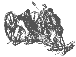 forced
the Confederates from the Cravens House, capturing it and the two
cannon. With reinforcements from the top and the eastern side of the
mountain, the Confederates established a battleline about 400 yards
beyond the Cravens House. This line, which prevented the Yankees from
capturing the Summertown Road (the only road up the mountain) was
held until 2:00 am on the 25th. By this time, the Rebels on the
mountain had withdrawn toward Missionary Ridge. forced
the Confederates from the Cravens House, capturing it and the two
cannon. With reinforcements from the top and the eastern side of the
mountain, the Confederates established a battleline about 400 yards
beyond the Cravens House. This line, which prevented the Yankees from
capturing the Summertown Road (the only road up the mountain) was
held until 2:00 am on the 25th. By this time, the Rebels on the
mountain had withdrawn toward Missionary Ridge.
|
The
Confederate artillery on Lookout Mountain was ineffective due to
cloud cover and the steep angle of fire. The
Confederates fired 33 times on the western side and 30 times toward
the Cravens House. |
|
It started raining about
4:00 pm on the 24th and that night was cold. Wet soldiers on both
sides spent the evening shivering and doing their best to say warm.
Before daylight on Nov. 25, not knowing if the Rebels had withdrawn,
Union volunteers scaled the Palisades at Roper's Rock and found the
Confederates gone from the top. The
Battle Above the Clouds was over. |
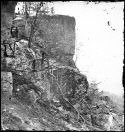
Roper's Rock |
|
The name
"Battle Above the Clouds" was
given the battle after Union General Meigs reported that the battle
had been fought "Above the Clouds". |

|
Chickamauga
and Chattanooga
National
Military Park
Visitors
to Lookout Mtn and the Chickamauga and Chattanooga National Military
Park can see many of the sites that existed during the battle. The
Cravens House, destroyed during the fighting has been restored to its
original condition, the captured cannon are still there as well as
the remnants of the Confederate breastworks. The final Union and
Confederate battlelines can be seen and the site where Union
volunteers scaled the Palisades. Standing on Sunset Rock and The
Point, all the Chattanooga battlefields can be seen. And the park
trails run along the same path used by the Union soldiers as they
advanced against the Confederates. |
|