|
Starving in Chattanooga
 he
Yankees were starving in Chattanooga. The only supply line open went
through a very rough mountain range. Another supply line had to be
opened or the Confederate strategy of starving the Union forces into
submission might succeed. he
Yankees were starving in Chattanooga. The only supply line open went
through a very rough mountain range. Another supply line had to be
opened or the Confederate strategy of starving the Union forces into
submission might succeed.
The only possible supply
line would have to go through territory controlled by the
Confederates in Lookout Valley. The key to establishing this supply
line was Brown’s Ferry. The Union had control of the northern
bank (on Moccasin Bend) at Brown’s Ferry but Confederates held
the opposite bank.
|
A line
of hills border the southern bank of the Tennessee River in this area.
These hills rise steeply forming a bank that towers
75
feet above
the river. Brown's Ferry was located at a gap in this line of hills. |
About 3:00 am on the
morning of Oct 27, 1500 men under General William Hazen got into 50
pontoon boats in Chattanooga and quietly floated down the river (the
Confederates controlled the river past Chattanooga). Another 3500 men
under General John Turchin crossed the river at Chattanooga and went
across Moccasin Bend to the bank opposite Brown’s Ferry. About
5:00 am the Union 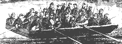 forces
landed at Brown’s Ferry. They confronted a small force of
Confederates under the command of General Evander Law and Captain
William Oates. forces
landed at Brown’s Ferry. They confronted a small force of
Confederates under the command of General Evander Law and Captain
William Oates.
When Oates learned the
Yankees had landed at Brown's Ferry, he immediately attacked with his
entire force of six companies (about 250 men). In the early morning
darkness, Oates thought he was facing about 100 Yankees but soon
learned he was greatly outnumbered. He ordered a retreat but not
before suffering a serious leg wound.
By that afternoon, Union
forces had built a bridge across the river (using the pontoon boats)
and opened a new supply line called "The Cracker Line". The
Confederate blockade had been broken. The question now was whether
the Yankees could hold Brown's Ferry. See Maps
|
The
Cracker Line, named after a hardtack cracker eaten by soldiers, ran
from Bridgeport AL up the river to Kelly's Ferry (close to the
entrance of TVA's Raccoon Mtn. Pump Storage Facility) through a gap
in Raccoon Mountain (current Hwy 41) to Brown's Ferry. It then
crossed the river to Moccasin Bend and on to Chattanooga (crossing
the river once more). |

Securing
The Cracker Line
After Brown's Ferry, the
Union strategy was to secure Lookout Valley and protect the Cracker
Line. To do this, days before Brown's Ferry, the Union's Army of the
Potomac under General "Fighting Joe" Hooker was ordered to advance from Bridgeport Alabama
(about 25 miles southwest of Chattanooga) into Lookout Valley.
Joe" Hooker was ordered to advance from Bridgeport Alabama
(about 25 miles southwest of Chattanooga) into Lookout Valley.
Hooker and The Army of the Potomac
On October 28, the day
after Brown's Ferry, Bragg and Longstreet (who was in command of the
Confederate left wing on Lookout Mountain and Lookout Valley) were
told that a large force was marching down Lookout Valley. Bragg
didn't believe the report, so he and Longstreet went to Sunset Rock
and there saw Hooker and 6500 soldiers from The Army of the Potomac
marching toward Brown's Ferry. As they watched, 1500 soldiers stopped
and made camp at Wauhatchie. The remaining soldiers advanced 2 miles
further. Bragg then ordered Longstreet to attack.
|
Wauhatchie
was a train depot located on
the west side of Lookout Creek, just below
Sunset Rock and 3 miles from Brown’s Ferry. |
At Wauhatchie, the
Yankees under General Geary made camp and placed their cannon battery
on a small knoll. Geary's son was in command of the battery. |